Marine Habitat Loss Mapping
Identification and prioritisation of tidal exclusion structures for objective management and rehabilitation decision making.

Mapping the loss and modification of intertidal wetlands in Central Queensland
Mapping the loss and modification of intertidal wetlands in Central Queensland: Identification and prioritisation of tidal exclusion structures for objective management and rehabilitation decision making.
What is the project about?
The long term project outcomes are to provide policy makers and natural resource managers the information required to make objective decisions regarding the management and rehabilitation of intertidal wetlands in Central Queensland.
Background
Intertidal wetlands are disappearing. Many of these complex habitats at the transition zone between the freshwater and marine environment have been lost or modified as a result of urban and agricultural development, and what remains intact is under threat from rising sea level and future coastal development.
Encompassing the area from upper tidal salt marshes through to mangrove lined estuaries, intertidal wetlands provide critical nursery and refuge habitat for many coastal and coral reef fish, and crustaceans species (e.g. barramundi, sweet-lip emperors, mud crabs and prawns). These highly productive and incredibly diverse ecosystems also provide an important buffer zone, limiting the transfer of nutrients and sediment to the Great Barrier Reef. Intertidal wetland habitats must be conserved, managed and rehabilitated so that the vital ecological, economic and social services they provide can continue into the future.
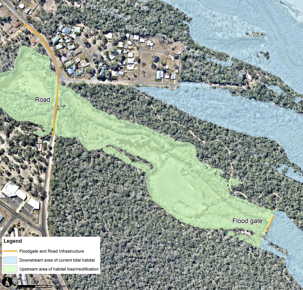
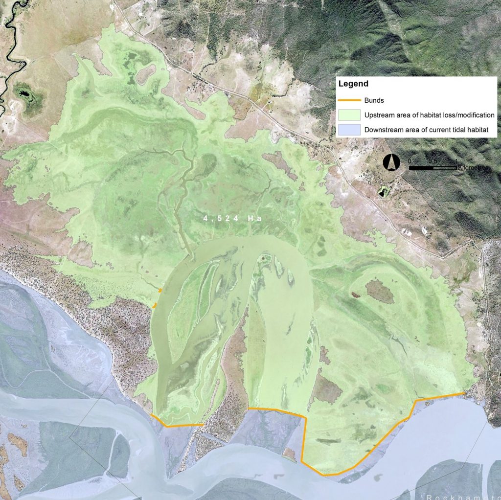
Much of the loss and modification of intertidal wetlands can be attributed to the installation of tidal exclusions structures. For example tidal bunds constructed to increase usable pastoral and agricultural land, levy banks and flood gates to protect coastal urban developments and road and rail infrastructure to transport people and goods. With increased investment for the management and rehabilitation of intertidal habitats there is a pressing need to identify and prioritise tidal exclusion structures and the associated wetland impact. This information will be vital for decision makers when allocating funds for on-ground management or rehabilitation works— given the often short amount of time available to locate appropriate sites and complete works.
Project area
The mapping and prioritisation encompass the Capricorn coasts of Livingstone, Rockhampton, Gladstone and Bundaberg local government areas.
Objectives
The objectives of this project are to:
- Catalog tidal exclusion structures within the project area. Physical and spatial attributes will be assigned to the structures to provide relevant information for future management decisions.
- Prioritise tidal exclusion structures for ongoing management and rehabilitation of intertidal wetlands.
- Provide preliminary rehabilitation options assessments for priority locations to assist relevant stakeholders with objective rehabilitation decision making.
- Release reports and mapping products related to the project through open data source platforms such as Queensland Globe, WetlandInfo and WetlandMaps.
Project activities
- Inventory all structures that exclude/restrict tidal movement.
- Determine the area of tidal wetland impacted as a result of the structures.
- Develop and apply a multi criteria ecological prioritisation to focus on ground resources objectively.
- Consult with stakeholders e.g. land holders, natural resource managers, management authorities, and collate information relating to specific structures.
- Further prioritise structures based on social and economic values.
- Ground truth priority structures, collecting relevant information for future management or rehabilitation works.
- Undertake preliminary options assessment for potential on ground rehabilitation works at feasible locations.


Key Stakeholders
Land holders/asset owners
Regional councils
- Livingstone
- Rockhampton
- Gladstone
- Bundaberg
State Government
- Department of Agriculture and Fisheries
- Department of Environment and Heritage Protection
Gladstone Ports Corporation
Activities
• Finalisation of tidal exclusion structure catalogue
• Tidal exclusion structure impact mapping – preliminary estimations of affected habitats
• Expressions of interest to join the prioritisation technical advisory group
• Development of multi criteria ecological prioritisation
• Consultation with landholders and asset owners to arrange access for site assessments
Get involved
If you are involved in the research, management or rehabilitation of intertidal habitats, or would like more detailed information about the project, we would like to hear from you. Send Trent Power an email to find out more. If you would like to receive project updates please email us to join the mailing list.
Project funding
The Department of Agriculture and Fisheries is funded the project for the provision of rehabilitation and management of fish habitat in Central Queensland under DAF1498CQA-6 and DAF1498CQA-7.
For more information contact Trent Power at Catchment Solutions.


