• Skip to primary navigation
  • Skip to main content
Featured Project: large, engineered log-jam structures to stabilise actively eroding streambank
catchment-solutions-logo
catchment-solutions-logo-white
Search
  • Home
  • About
    • Vision, Capabilities & Values
    • Our board
    • Our team
    • Positions vacant
  • Services
    • Water Quality Services
    • Agricultural Innovation and Support
    • Fisheries & Aquatic Ecosystems
    • Environmental Planning & Approvals
    • Ecosystem Rehabilitation & Repair
  • Projects
    • Featured Projects
    • Agricultural Innovation and Support
    • Ecosystem Rehabilitation & Repair Projects
    • Environmental Planning & Approvals
    • Fisheries & Aquatic Ecosystems
    • Water Quality Services
    • Archived Projects
  • News
  • Media
  • Contact
Project enquiry
Hide Search

erosion

Collinsdale Erosion Remediation Project

diana · Sep 23, 2019 ·

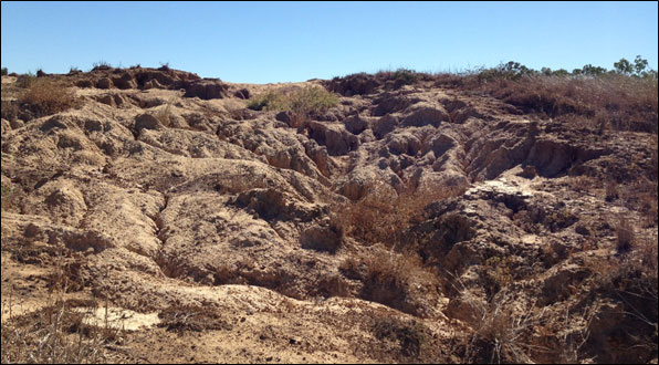
Catchment Solutions have recently (August 2019) commenced on-ground works at the Collinsdale erosion remediation project site. The primary erosion remediation site is located at the Collinsdale Station, which is situated on the southern side of the Fitzroy River, in Garnant, approximately 30km from Rockhampton. The 450ha cattle property is situated within the Louisa Creek catchment and has been identified through Paddock to Reef modelling as contributing the 10th highest load of sediment to the Great Barrier Reef Marine Park from the Fitzroy basin area.

The Reef Trust IV Erosion Remediation project area includes the rehabilitation of large-scale gully erosion, using earthworks to reshape and fill the erosion scar, with the project, including;

  • Approximately 20,000m3 of material being moved and reshaped,
  • 10km of river and streambank fencing to be installed,
  • the construction of a large farm dam (excavated to provide fill for earthworks and to provide a high-capacity off-stream watering point), and,
  • the installation of 7 off-stream watering points, restricting cattle from accessing water directly from the Fitzroy River.

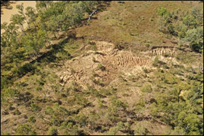
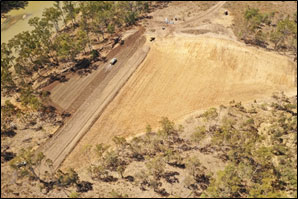
Figure 1. Before (left) and after (right) images taken from a drone of the primary project site, showing significant gully erosion in pre-construction image and cut, fill and reshaping earthworks in post-construction image.

Following the completion of earthworks, which is anticipated to be late 2019, the site will have irrigation installed and be seeded, mulched and revegetated to reduce rainfall impacts on the rehabilitated gully area. The adjacent property located directly upstream, the Bindaree station, will also include an additional 4km of streambank and gully fencing.


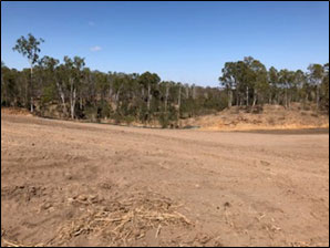
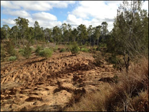
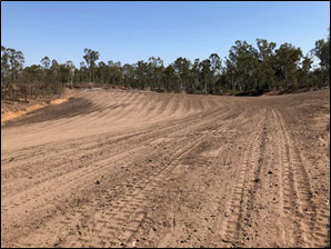
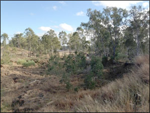
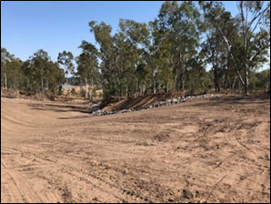
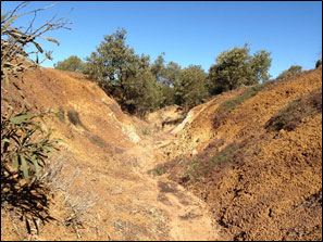
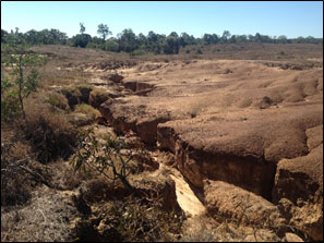
Figure 2. Before (left) and after (right) images taken from around the primary project site, showing significant erosion issues in pre-construction images and fill and reshaping earthworks in post-construction images.

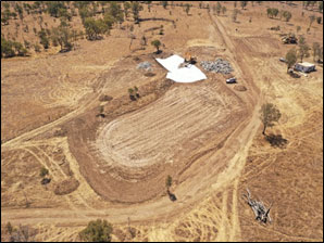
Figure 3. Before (left) and after (right) image taken from a drone of the large farm dam excavations, around the primary project site, with spillway formalisation works still being completed in the image on the right.

Ogmore Erosion Remediation Project

diana · Sep 23, 2019 ·

In early 2019, Catchment Solutions commenced a project aimed at addressing severe erosion in the Ogmore area of the Styx River catchment, funded through Reef Trust IV. Due to the sodic nature of the soil found within the Styx River Catchment, even with restricted grazing, active gully erosion is occurring at a significant rate. Paddock to Reef modelling has demonstrated that the Ogmore area contributes 26,880t of fine sediment to the Great Barrier Marine Park per year.
Severe erosion at Ogmore.
Figure 1. Severe erosion representative of the catchment land issues throughout the Ogmore region.
To minimise ongoing erosion, six demonstration trial plots are to be set up at the Oakdean Station, to assess and demonstrate various erosion remediation methods intended for future adoption of these methods throughout the broader Ogmore area. Erosion treatment methods to be trialled include combinations of gully reshaping, ripping (shallow <200mm), gypsum treatment (10t/ha), lime treatment and (2t/ha) and rhodes grass seed application (10kg/ha). Additionally, following any earthworks, mulching by Conservation Volunteers Australia will be undertaken to reduce rainfall impacts on the rehabilitated gully areas.

On completion of the project, the demonstration site will be used to hold remediation workshops to local landholders within the Ogmore area, providing for expansion of the treatments to other similar sites owned by neighbouring landholders within the catchment.

On-ground trial works of the project are anticipated to commence in October/ November 2019.

Ogmore remediation project.

Figure 2. Additional gully erosion images from throughout Ogmore, where remediation trials will commence in late 2019.

Erosion remediation at Collinsdale

diana · May 7, 2019 ·

Catchment Solutions is leading the remediation of large-scale erosion at the Collinsdale property located about 30 kilometres north of Rockhampton.

The Collinsdale property is situated in the Garnant locality.  This project involves the rehabilitation of  large scale gully erosion using earthworks to reshape and fill the erosion scar, with about 20,000m3 of material to be moved and reshaped.  Following reshaping, the site will be seeded and mulched to protect the top soil. The site will then be planted by Conservation Volunteers Australia with a mixture of native trees and bushes to enhance re-vegetation of  the site.

To protect the site following remediation, fencing of the site and surrounding catchment along Louisa Creek will be undertaken.  This fencing will be combined with the installation of off-stream watering points.

On behalf on Catchment Solutions, Neilly Group Engineering has undertaken flood modelling and a detailed design to undertake the remediation of the large-scale gully erosion. The attached video outlines the site planning and monitoring undertaken to obtain relevant government support and approval.

This project has been endorsed by the Reef Trust Technical Working Group  (Gully and Stream Bank  Erosion Control Program) and approved by the Department of Environment and Energy.

The project will be tendered in May 2019, with the project earthworks expected to begin by August 2019.

ACCESS TENDER DOCUMENTS HERE

This project is funded by the Australia Government through the Reef Trust Program.

Search

catchment-solutions-logo-white
  • PO Box 815
    Mackay QLD 4740

  • +61 (07) 4968 4216

  • info@catchmentsolutions.com.au

Tailored End-to-End Environmental Solutions

Helping clients Australia-wide to manage, design and execute projects to meet high standards of environmental excellence and corporate responsibility.

© 2022 Catchment Solutions · WordPress by The DMA
  • Legal
  • Privacy